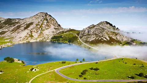
The spectacular Picos de Europa, which spread across northern Spain, are home to caves, gorges, walking trails — and the local speciality, Cabrales cheese.
“It’s like
cheese under here,” I overheard a Spanish hiker say to his companion, high on
the slopes of Spain’s Picos de Europa mountain range.
He was describing
the multitude of caves that puncture the limestone slopes that spread across
Asturias, Cantabria and Castilla y Leon regions in northern Spain. But if it
was meant as a simile, it could also be taken literally — because in a number
of these caves, the local speciality, Cabrales cheese (a blue cheese similar to Roquefort) is quietly ageing in the
gloom.
It is this
cheese that gives the mountains much of their character. The Picos de Europa
was Spain’s first
national park, and it is a place where cows and goats still graze purely to
maintain the local cheese industry. As they trim the grassy slopes of heather
and gorse, they also open up spectacular views across the massif.
Rising to 2,648m
above sea level at their highest point and stretching just 40km in length, the
Picos de Europa — the Peaks of Europe — were apparently so named because they
were the first piece of European land sailors sighted when coming across the
Atlantic. Though virtually unknown compared to the likes of the Alps, Pyrenees
and Dolomites, there is much to prove the Picos worthy of their grand name.
Two of the
Picos’ caves, the Torca del Cerro del Cuevon and the Sima de la Cormisa, are
among the deepest in the world, both plunging more than 1,500m into the earth .
The mountains are gouged across by the Garganta
del Cares, a gorge almost as deep as the Grand Canyon. And sat atop the
range like a rocky prong is the peak of Naranjo de Bulnes, its shape more akin
to the mountains in the windy wilds of Patagonia than the northern coast of
Spain. This 500m-high fang of rock dominates the massif, and it is arguably the
most striking peak in Spain. Rock climbers revere it for its long, exposed
climbs, and for walkers it is the most magnetic destination in the Picos thanks
to its dominating bulk.
The popular
10km trail to reach the base of Naranjo de Bulnes begins at the mouth of the
Garganta del Cares in the village of Poncebos, 6km from the popular tourist
town of Arenas de Cabrales. Walk this route and you will discover a place where
mountain life has retained an authentic, unpolished edge. There are stone
villages like Bulnes, 3km from Poncebos, still yet to be connected by road.
Shepherds wander the slopes, herding goats along the trails and alpine expanses,
beginning the cheese-making process. Even track notes caution about goat fleas
rather than the usual bears or snakes. It is a journey that ascends through
mountain pastures towards the barren heights of the range, peering deep into
valleys and gorges and up to raw and rocky mountains. The scenery belies the relatively
low altitudes, with great alpine hiking at just 2,000m above sea level.
At day’s
end, the Vega de Urriellu
mountain refuge at the base of the peak is the only accommodation option, offering
basic meals and dormitory beds to walkers and climbers — but a night here is
an essential part of the Picos mountain experience. In the evenings, chamois (a goat-antelope species native to mountains in Europe) click
across the surrounding rocks, and if the weather is clear you get the most
unusual of mountain views, peering down onto ships far below on the Atlantic
Ocean.
Once you
have walked on the mountains, the most common way to get inside them is by
hiking into the Garganta del Cares. This gorge wriggles through the Picos for
11km, with limestone cliffs and mountain slopes rising up to 1,500m overhead. Blasted
into the limestone cliffs, and at times burrowing through them, is a walking
track, the Ruta de Cares, which is said
to be one of the busiest trails in Spain with up to 3,000 hikers each day in
summer. It may also be one of the most spectacular walks in the country.
From
Poncebos, the trail rises up the gorge beside a channel that feeds water to the
hydroelectricity plant powering Arenas de Cabrales. Far below, beside the
gin-clear Cares River, is the remnant of a road that authorities tried to
whittle through the gorge before Word War II. The folly of the exercise is
quickly realised down the route as the gorge becomes little wider than a footpath.
The road may have failed, but the walking trail is a marvel in itself. Dynamite
scars remain imprinted in the cliffs, and walkers pass through a multitude of
small tunnels as the gorge thins towards the village of Cain. Finally, the
river becomes so narrow — if you were to stand in the middle of the riverbed,
you could just about touch both rock walls — and the cliffs so steep, the
trail is forced into a tunnel several hundred metres long.
At the
tunnel’s end, the gorge butterflies into a wide valley enclosing the town of Cain.
A soundtrack of rushing water is audible throughout Cain, a town filled with
hotels, souvenir stands and restaurants. It is a chance to rest and perhaps try the local
cheese, tucking into tapas at one of the many restaurants, before beginning the
return walk back through the gorge to Poncebos.